Stay with the Free Press for coverage of Hurricane Sandy. We are watching local news sources and the weather bureau, as well as monitoring McDaniel Alerts for the latest details, and will pass on any information about how the storm will impact Westminster as it becomes available to us. In the event of a power outage, we will lose Internet access, but will continue to do our best to send out updates using our 3/4G via Twitter (@mcdfreepress); the Twtiter feed can also be seen at the top of our home page.
————–Oct 30, 6:46 PM———-
Thanks to those of you who followed the Free Press storm coverage. We hope you all made it through unscathed. Campus didn’t get hit too badly, but we know surrounding areas and the rest of the East Coast faced a lot of damage, and we send our thoughts to those of you who were affected.
Please remember that even though the worst is over, some roads are still closed from downed power lines and fallen trees, so drive carefully.
————–Oct 29, 6:48 PM———-
The weather station at Westminster’s East Middle School has recorded more than 5″ of rain today. As we wait for landfall and the worst of the storm to come tonight, you can follow the conditions live here.
————–Oct 29, 4:32 PM———-

————–Oct 29, 4:30 PM———-
We realize that it’s exciting to have classes cancelled (our reporters are happy about that, too), but please be prepared, because this storm is historically unprecedented:
“If anything, Sandy is exceeding the forecast expectations, and the forecast was for a storm of epic proportions and effects.” – Bryan Norcross, hurricane specialist for The Weather Channel.
Read more about what the experts say here.
Don’t forget that you can call Campus Safety in an emergency, or if you have any questions or concerns: 410-857-2202.
————–Oct 29, 4:26PM———-
The Weather Channel has posted their latest Top 5 list of things you need to know about Sandy right now:
Hurricane Sandy picked up strength and speed this morning and is now nearing landfall. Landfall should occur near extreme southern New Jersey or central Delaware by late afternoon or early evening.
They also have a live news feed, but this one is less localized than the Patch one posted earlier.
————–Oct 29, 4:15 PM———-
Road closures are posted here, but you shouldn’t be driving at all. Stay inside and stay safe.
Also, Governor O’Malley has said that Early Voting days lost to the storm will be made up at the end of the week:
————–Oct 29, 4:03 PM———-
Patch has set up this live chat to monitor Sandy conditions in our area.
Police are urging people to stay off the roads, according to Westminster Patch.
Additionally, the State has lowered highway speed limits to 45 mph.
High winds have resulted in closures of several roads and bridges, including the Chesapeake Bay Bridge.
Expect 8-12 inches of rain. The worst of the storm should be between 6 PM tonight and 6 AM tomorrow.
This means that you should charge everything electronic that you will need, because it is predicted that millions of people are going to lose power.
Keep checking back here for the latest updates, and don’t forget that if we lose power, we’ll continue to keep track of the storm with Twitter (@mcdfreepress).

————–Oct 29, 3:38 PM———-
McDaniel College has cancelled all classes for Tuesday, October 30.
The eye of Hurricane Sandy is now expected to make landfall in New Jersey in the 6:00 p.m. hour, sooner than expected.
————–Oct 29, 1:48 PM———-
Carroll County is under a flood warning.
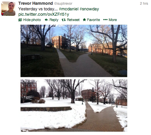
On a lighter note, here’s what some students have done to wait out the hurricane:

Photo by Lauren Murray
Juniors Lauren Murray, Hillary Deweese, Meghan Shatz, Hannah van der Veken and Luis Ortiz crafted a fort out of sheets and pillows in order to celebrate cancelled classes during Sandy.
Send your hurricane photos to freepress@mcdaniel.edu.
————–Oct 29, 1:35 PM———-
To track power outages in our area, use this link.
————–Oct 29, 11:28 AM———
Governor O’Malley has said that some Marylanders will die. He urged residents to stay inside for the next 24-36 hours, according to Patch. com.
————–Oct 29, 11:26 AM———
The National Hurricane Center’s latest advisory warns of sustained winds of up to 90 mph. Sandy is expected to weaken when moving inland, but not enough that it still shouldn’t be taken seriously.
————–Oct 29, 11:14 AM———
This morning, McDaniel students received several emails from the College.
The Athletics Department sent out hours of operation for campus recreational facilities:
Gill Center Gym is open 9:30 a.m. until 7 p.m.Merritt Fitness Center is open 11 a.m until 7 p.m.Harlow Pool is open from 2 until 5 p.m.
IT explained that because we use two Internet vendors, it is possible that we will have partial Internet usage if only one of them loses power. However, if this does happen, the Internet should be reserved for emergency use.
They also recommend to charge electronic devices now while we still have electricity, especially those with SmartPhones will be relying on 3/4G if we don’t have Internet.
“Please be respectful of internet use during the storm. We appreciate that with no classes there will be a greater use of the internet for entertainment, especially streaming video,” said the email. ” Should the power fail, internet service will become less responsive and should be reserved for emergency communications. Please respect the needs of others.”
Additionally, if we lose power/Internet, OneCard services will not work, according to another email from IT. Some services have a cash option, and Glar and the Pub will use paper transactions.
————–Oct 28, 11:07 PM———
Here’s some hurricane safety tips from The Baltimore Sun, BGE, and World Weather Travellers Guide:
1) Disconnect electrical equipment that is not connected to a surge protector in order to prevent a fire in the event of a power surge.
2) Do NOT go outside if it is suddenly calm outside- this means you’re in the eye of the storm, and the worst is yet to come.
3) Stay inside. If you have to go outside, try to wear stronger clothes that will better protect you from flying debris. But probably, just don’t go outside until you are officially told that the hurricane has passed.
4) Keep the following items nearby: a flashlight with extra batteries, a three-day supply of water (one gallon per day per person), a first aid kit, and a battery operated radio, and non-perishable food.
5) Keep your phone and laptop charged and ready for a power outage, in order to receive emergency communications.
6) Secure anything that can be picked up by the wind, because it could end up a projectile.
7) Close windows.
8) Familiarize yourself with the evacuation plan that should be posted on your residence door.
9) Don’t drive anywhere if you can help it. If you can’t, then don’t drive through flooded areas. Even if the water doesn’t look that deep, the current can still be very strong.
10) Use flashlights, not candles, because the flame could ignite a gas leak if one were to occur.
11) Call Campus Safety if you need anything: 410-857-2202.
12) Don’t panic. The College is working to keep us all safe.
————–Oct 28, 9:04 PM———-
ResLife just sent out an email that confirmed that not only are classes cancelled tomorrow, but campus events as well. Campus Safety and Dining Services are the only offices that will remain open tomorrow.
While Casey’s Corner will be closed, Glar, the Pub, and the Green&Go are all to remain open for regular hours as of right now.
Don’t forget to gather personal property from outside to be stored indoors during the storm. “Lets avoid having extra items that could get caught up in the wind,” warned Michael Robbins, Director of Residence Life, in the email. He also warned students to close their windows to prevent rain from coming into buildings.
————–Oct 28, 8:39 PM———-
The Baltimore Sun reports that Sandy has killed 66 people already.
————–Oct 28, 8:34 PM———-
BGE expects several hundred thousand customer power outages from Hurricane Sandy, and has already requested almost 2,000 out of state crews to help fix the likely damage to power lines, according to this press release.
They have issued a warning to avoid entering flooded rooms, especially if the water covers power outlets, in order to prevent risk of electrocution.
In case of emergency, call Campus Safety: 410-857-2202.
————–Oct 28, 8:13 PM———-
Hurricane Sandy is “history in the making,” according to the Weather Channel’s list of top 5 things you need to know.
The Batlimore Sun reports that Sandy is a “once-in-a-lifetime storm,” due to a dangerous combination of not only the hurricane, but North Atlantic conditions that will prevent the storm from moving out to sea as well as a cold front coming in from the West that will leave some states with snow (but probably not Maryland). The Associated Press explains in more detail why this is.
Noon tomorrow until midnight Tuesday is supposed to be the worst part of the storm, reported the Baltimore Sun this evening. The Sun also reported: “Hurricane-force winds extend 105 miles from the storm’s center, while tropical storm-force winds reach as far as 520 miles out, making Sandy an extremely large and powerful cyclone.”
Flooding is anticipated, so be careful of standing water.
The Weather Channel is compiling live Twitter updates here.
————–Oct 28, 8:04 PM———-
Check out this wind map, an art project that represents wind speeds across the country. It’s a fascinating way to watch the hurricane from the safety of your Internet.
————–Oct 28, 8:01 PM———-
The storm is looking to be the worst on Monday and Tuesday, with wind gusts up to 60 mph, according to Westminster Patch.
From the City of Westminster, MD:
IMPORTANT STORM INFORMATION – HURRICANE SANDY
The City of Westminster is conducting the necessary planning for the arrival of Hurricane Sandy over the coming weekend. Hurricane Sandy is expected to arrive in our area as a tropical storm on Sunday evening, bringing with it 35-45 mph sustained winds and 6-12 inches of rain. The storm is currently anticipated to affect our area from Sunday evening through Tuesday evening. A storm of this magnitude is likely to create widespread power outages and localized flooding conditions. Preparations are underway to ensure essential City services throughout the duration of the storm. Residents are encouraged to minimize their travel during the peak of the storm.
————–Oct 28, 7:57 PM———-
Emergency shelters are now open.
- Century High School, 355 Ronsdale Road, Sykesville
- Winters Mill High School, 560 Gorsuch Road, Westminster
Tune in to local cable stations 19, 23, and 24 for updates on the storm.
————–Oct 28, 7:49 PM———-
Remember to stay away from standing water, avoid driving if at all possible, and program Campus Safety’s number into your phone: 410-857-2202.
The Weather Channel will be streaming information 24/7 online, just in case we lose power, so you can get information from your mobile device. They’re taking the storm very seriously, because it is “mixing with other weather systems to create a storm of unprecedented strength in the region,” according to this Carroll County Times article.
Mandatory evacuations from Ocean City are taking place, so try to stay away from Route 50- it’ll be quite congested.
Want more information about Sandy? Here’s some more resources.
————–Oct 28, 7:45 PM———-
Early voting is cancelled for Monday.
————–Oct 28, 5:42 PM———-
It is estimated that 10 million people will lose power from Sandy. To find out what McDaniel is doing to prepare, check out this article. To stay up to date on Carroll County news about the hurricane, Westminster Patch (edited by our faculty advisor) has set up this hub.
Don’t forget that Campus Safety can be reached 24/7 at 410-857-2202 in case of emergency.
————–Oct 28, 5:31 PM———-
Classes are cancelled for tomorrow, October 29. Stay safe, everyone!
Also, President Obama has signed an emergency declaration for Maryland.
————–Oct 28, 4:28 PM———-
Carroll County Public Schools, Carroll County Government, and Carroll Community College are all shut down for tomorrow.
————–Oct 28, 1:40 PM———-

If you haven’t been following Campus Safety’s Facebook updates, please remember that they are also tracking the storm and will let you know if class cancellations occur. They have advised commuter students to use their judgment to determine whether or not it is safe to travel to school, according to their Facebook page.
The Department of Campus Safety has also posted a link to McDaniel Alert. If you have not yet signed up, please do so in order to receive notifications to your phone of important safety messages. Use your Student ID number (without the extra zeros at the beginning) as your username, and your McDaniel password.
The Carroll County Office of Public Safety is also posting updates about the storm. Above, they have provided an information hotline.
Remember that if there is an emergency, call 911 and Campus Safety at 410-857-2202.
————–Oct 27, 1:08 PM———–
Welcome to the first ever McDaniel Free Press liveblogging experience. Check back for updates on the storm, photos, and more. Want to be involved? We’ll be monitoring hashtag #mcdsandy to get the opinions and experiences of the McDaniel College community. We also want your photos; email photos, comments, and questions to freepress@mcdaniel.edu.